Day 1 Arrival in Kathmandu
It is a panoramic thrill flying into Kathmandu on a clear day. The views of snow-capped mountain peaks sprawling down below you are almost ecstatic, beginning a whole chain of memorable experiences that stay with you for a long, long time. A representative and driver from our office will meet you at the airport and escort you to your hotel. The representative will help you check into your designated hotel. At the hotel you will be briefed about your daily activities.
Day 2 Sightseeing of Kathmandu Valley
Kathmandu is the historical and cultural heart of Nepal and has been a popular destination for tourists ever since Nepal opened its doors to visitors. The city presents a wonderful mix of Hinduism, Tibetan Buddhism and Western influence in the Valley. Patan and Bhaktapur, its two major neighboring cities bear immense historical, cultural and religious significances. There will be a half day guided tour to the famous and biggest Hindu shrine of Pashupatinath, the largest Buddhist stupa in Nepal Boudhanath, the 15th century Palace of 55 windows and Swoyambhunath.
Day 3 Drive to Besi Sahar [820m] [drive approx 6 hours] and Trek to Bulbule
With high level of physical fitness, adequate acclimatization and good logistic support, we begin our Annapurna trekking. Driving along the Kathmandu-Pokhara Highway to Dumre and then following the rough route by the Marsyangdi River, we pass through the low-lying villages and rice fields. After 6 hours long drive, we finally reach Besi Sahar. Besi Sahar is the capital of Lamjung District.From Besi Sahar, we trek along the trail turning right at the canal on the outskirts of the village and descending the narrow path to the Pam Khola. On crossing the stream, we ascend towards the village of Denauti where we get to see Nepali village life at close quarters. The route further leads to the banks of the Marshyangdi Khola, passing through paddy fields and subtropical forests. As the trail nears the Khudi Khola, we approach the Gurung village of Khudi. and Juft 20 minute hikt to Bulbule and overnight there.
Day 4 Trek to Jagat [1290m]
The trail goes uphill, we spot several shops and teahouses at Ngadi village. On leaving Ngadi after a brief rest, we skirt through the challenging trails to Bahundanda. Bahundanda literally means "Brahmin hill" and as the name suggests Bahundanda is largely inhabited by Brahmins. Here we conclude our trekking journey for the day.A steep trail descends from Bahundanda, through rice fields, before crossing a stream at the bottom of a small waterfall. It then climbs again and traverses the hillside high above the river before reaching the village of Hani Gaon. Ahead, the Marshyangdi valley forms a steep V-shape. We follow the winding mountain path down through Syange and along the river for some distance. The trail then climbs steeply and the path is cut into the sheer cliff-face some 200-300m above the riverbed. Eventually we descend to the stone village of Jagat, situated on a shelf, which juts out into the precipitous Marsyangdi valley.
Day 5 : Trek to Dharpani [1920m]
The trail from Jagat descends until it reaches the river and then continues through a lush forest. Further ascent leads to sharp-edged cliff facing the riverbank. En route, Chyamje comes into picture amidst the glorious backdrop of towering Annapurna mountain ranges. After crossing a suspension bridge, we climb steeply towards the slippery and physically challenging path to Sattale. On treading along a succession of rock-strewn trails, we descend to a grassy riverbank that leads to Tal. As we walk away from Tal, the path becomes rugged and winding. Then we approach steep forested village of Karte. Meandering along the waterfalls and cliffs, we finally reach Dharapani after crossing a suspension bridge.
Day 6 Trek to Chame [2630m]
We skirt through a narrow field from the village. The Dudh Khola, which originates from the south face of Manaslu and then Marshyangdi veers to the left. Sinuous trails of the. Annapurna II becomes visible as we arrive at Bagarchhap, a Bhotia village with colorful prayer flags fluttering in the breeze. As we continue ascending through forests of pine and oak, we pass through Dhanakyu before coming to a thundering waterfall. Further on, the Marshyangdi river enters a gorge and the trails follows rock-strewn path.We can pause for a while and take in the splendor of the picturesque Manaslu. When the steep incline ends, we follow a path amid magnificent rhododendrons and continue on a gently rising path. We cross a stream before entering a pine forest. We then enter the pristine hamlet of Kotho, from where we can capture the most enchanting view of Annapurna II. Treading further, the route reaches a large white gate with a corrugated iron roof, which is the entrance of Chame. Chame is the administrative headquarter of Manang district. There is electricity, wireless station, schools, shops, health post, post office, police check post, hotels, lodges and banks in Chame. The hot springs are the major attraction of this place.
Day 7 Trek to Pisang [3190m]
After a mesmerizing sight of the glowing Lamjung Himal [6893m] in the morning, we head off for Pisang. En route, we cross a large suspension bridge along Marshyangdi and approach houses and lodges on the northern side of the river. Our trekking trail meanders through barley field leading to Teleku at 2775 meters. As we leave undulating mountain passes, we enter fascinating apple orchard and near a bridge at 2840 meters. On crossing the bridge, the pristine hamlet of Bratang appears. History has it that Bratang used to be a Khampa settlement. A stone memorial of a Japanese climber has been built in this place.After leaving the forested village, the valley changes from a V-shape to a gentle U-shape. Before us, the Annapurna mountain range rears up. Further on, we continue our steep rock-strewn trails to the south side and cross a long suspension bridge at 3040 meters. At this vantage point on the bridge, we get to view Paungda Danda rock rising more than 1500 meters from the river. En route, we get to capture splendid views of Annapurna II rearing up on the east and Pisang Peak on the north-east. We cross a bridge and enter the village of Pisang.
Day 8 Trek to Manang [3520m]
As we continue with our trek, further afield from Pisang we head along a steep ridge savoring beautiful sights of the Manang valley and the Tilicho peak towering above 7132 meters. As we descend through Manang's airstrip, we come to Hongde lying beneath the gigantic Annapurna III on the north-east face. The route further leads to the wide plain of the Sabje Khola Valley from where we get the majestic view of Annapurna IV [7525m].Further on, we cross a wooden bridge, as the Marsyangdi Khola gushes below us. We enter the beautiful village of Mungji. We continue treading along the cultivated fields and after a while we arrive at the village of Bryaga with a splendid monastery. On trekking down to Manang, we enjoy the majestic views of the Annapurna range - Annapurna II, Annapurna III, Annapurna IV, Gangapurna [7455m] and Tilicho Peak [7134m].
Day 9 Rest day in Manang [3520m]
After reaching Manang, we take a day off for complete rest and adequate acclimatization before crossing the Thorung La. We can spend this day strolling down the river to see the tremendous ice-fall cascading down from the glaciated mountain peaks or by simply take in the panoramic beauty of the Annapurna mountain range and the Manang Valley. A short visit to Himalayan Rescue Association [HRA] aid post makes for an interesting visit.
Day 10 Trek to Letdar [4250m]
Thoroughly acclimatized, we advance towards Thorung La. On the way, we cross a stream, climb to Tengi, 120meters above Manang and ascend further past Marshyangdi Valley turning north-west up the valley of the Jarsang Khola. Amid the spectacular vistas of Annapurna mountain range, we trek beyond the lush vegetation of scrub juniper and alpine grasses to reach the small village of Gunsang. Gunsang is a cluster of flat mud roofs just below the trail at 3960 meters. Along the route, we see several lodges.As we approach picturesque meadows and rich forests of barberry, juniper etc, we encounter horses and yaks grazing. The trail takes us further along a large stream that flows from Chulu West and Gundang, and leads to a rich pasture at 4000 meters.
Day 11 Trek to Thorung Phedi [4500m]
Leaving Letdar, we climb gradually to a ridge before descending to the headwaters of the Marshyangdi and crossing via a covered wooden bridge. After a short ascent up the mountain path on the right bank, we follow a narrow trail across an unstable steep slope and then descend to Thorung Phedi.
Day 12 Trek to Muktinath [3800m]
We have an early start today for the crossing of Thorung La [5416m]. The trail becomes steep immediately on leaving camp, but as local people have used this trail for hundreds of years, the path is well defined. The gradient then eases and after around 4 hours of steady climbing, we reach the chorten and prayer flags of the pass. From the snow-covered mountains above, to the head of the Kali Gandaki valley below and the brown and purple hills of Mustang, which spread out before us, we are presented with a dramatic tableau.
The descent to Muktinath is a 1600m trek. But the excellent views of Dhaulagiri, more then makes up for the tiring journey. Eventually the moraines give way to grassy slopes before a pleasant walk along the Jhong Khola Valley to Muktinath, with its shrines and temple.
Day 13 Trek to Marpha [2665m]
We now begin the descent down the dramatic Kali Gandaki Gorge. After passing through Jharkot and Khingar, villages with typical Tibetan architecture, we follow the valley floor most of the way to Jomsom. Jomsom is sprawled along both banks of the Kali Gandaki and from here we get fine views of the Nilgiri peaks. We continue down to Marpha, a delightful Thakali village, with a well-planned drainage system. Its narrow alleys and passageways provide welcome shelter from the strong winds of the Kali Gandaki Gorge. Marpha is particularly well known for its apples, apple cider and apple, apricot and peach rakshi.
Day 14 Trek to Lete/kalopani [2470m]
We continue descending the Kali Gandaki Gorge to Tukuche, a Thakalivillage with a large gompa. Beyond Tukuche we walk along the west bank of the Kali Gandaki towards Larjung. Here, as in many of the villages in this area, narrow alleyways and tunnels connect houses with enclosed courtyards, providing protection against the wind blowing up the valley. We make our way through pine, juniper and cypress forests to Kalopani, enjoying fine views of Annapurna I and Fang. We then reach Lete, which lies just twenty minutes beyond Kalopani.
Day 15 Trek to Tatopani [1160m]
Our trail descends steeply through forests to Ghasa, the last Thakali village and the southern-most limit of Tibetan Buddhism. We enter the steepest and narrowest part of the gorge shortly after Ghasa. At the hamlet of Rupse a magnificent waterfall tumbles down beside the trail. Continuing on, we come to Dana, a Magar village from where the massive peak of Annapurna South can be seen across the valley. The trail then descends to Tatopani where we can have apple pie and bathe in the hot springs.
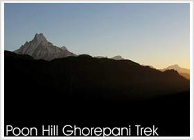
Day 16 Trek to Ghorepani [2775m]
A short distance downstream from Tatopani, we cross the river on a large suspension bridge and leave the Kali Gandaki behind. After passing through the villages of Sikha and Chitre, we climb through the forest to Deorali, a 2834m pass from where we can get excellent views of Dhaulagiri, Nilgiri, Annapurna I, Annapurna South, and Hiunchuli. Just 10 minutes beyond the pass is the village of Ghorepani. Ghorepani literally means "horse water" and is a welcome watering spot for the packs of mules, which ply the route between Pokhara and Jomsom.
Day 17 Trek to Birenthanti [1050m] & drive to Pokhara
Overlooking Ghorepani is Poon Hill [3193m]. An hour-long pre-dawn ascent gives us the opportunity to see the fascinating views of the Annapurnas and Dhaulagiri glowing in the morning sun. After breakfast, we begin the long descent to Birethanti through magnificent oak and rhododendron forests. From the village of Ulleri, a long steep stone staircase seems to go on forever before eventually reaching Hille. A more gradual descent then brings us to Birethanti, from where it is a short distance to the road and our transport that takes us to Pokhara.
Day 18 Explore around Pokhara City and Booking In Fewa Lake in Pokhara
After Long and Heavy Trekking Holiday you need small rest and relaxing. For That pokhara is perfect city .town for you can hang up yourself.
Day 19 Flight/drive to Kathmandu
We fly or drive to Kathmandu.
Day 20 Free Day in Kathmandu
In Kathmandu full day du it yourself tour around city and shoping free day preperation packing and etc.
Day 21 Depart Kathmandu
Our Nepalese support team will take you to the airport for your flight home. On the other hand, if you prefer to stay longer, you can go for short tours such as game drive at National parks, rafting, Tibet tours, mountain biking, etc.- ask us. |


 The Annapurna Circuit trek is the popular name for a 300 km trek in the Annapurna mountain range. The trek reaches an altitude of 5,415m on the Thorung -La pass, touching the edge of the fabled Tibetan plateau. The trek is a magnificent plan, covering two different river valleys. It encircles the Annapurna Massif, crossing Thorung La pass[5416m], the highest pass on this trek.